Hawaii, also known as the “Aloha State,” is renowned for its stunning natural beauty, with each island offering a unique experience. The Big Island, officially named Hawaii Island, is the largest and one of the most diverse in terms of landscapes and activities. If you’re planning a trip to the Big Island, a well-detailed map is essential for navigating its vast terrain. In this article, we’ll explore the Hawaii Big Island map, highlighting key attractions, top destinations, and tips for making the most of your trip.
Understanding the Hawaii Big Island Map
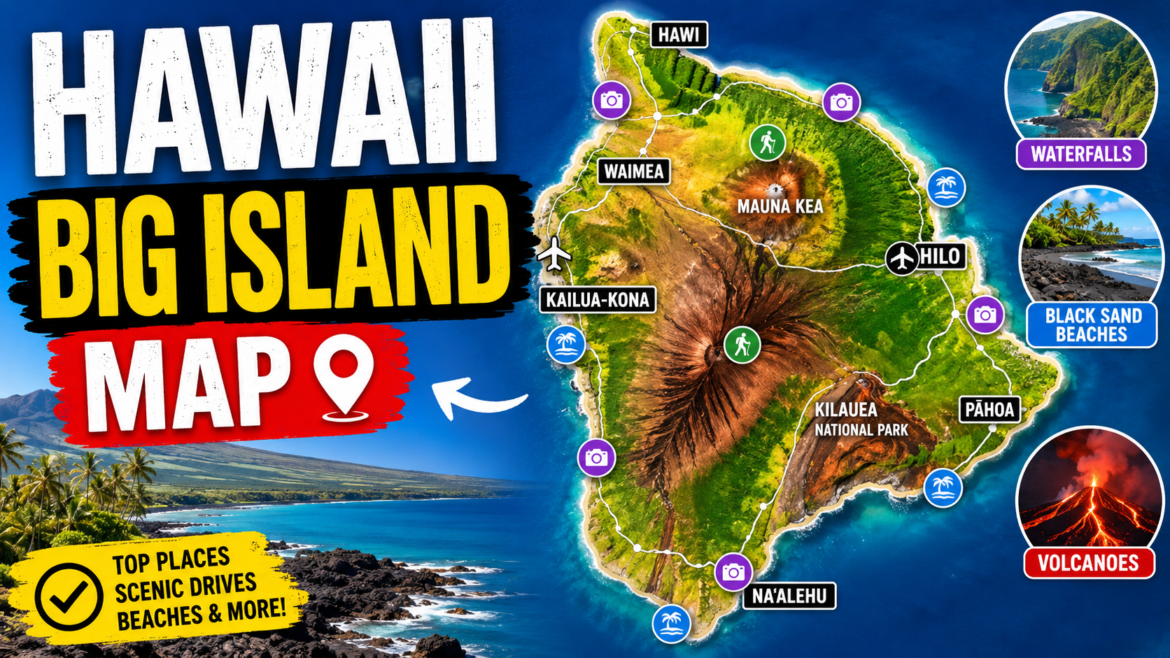
The Hawaii Big Island map provides an essential guide to exploring the island’s vast expanse. It encompasses diverse landscapes from active volcanoes to lush rainforests, pristine beaches, and expansive desert regions. The island is divided into several regions, each offering a unique blend of activities, culture, and natural beauty. Whether you’re planning to visit Kona, Hilo, or the volcanic parks, understanding the layout of the island is crucial for a smooth and enjoyable trip.
The Big Island’s geography is defined by the presence of five active volcanoes, including Mauna Kea and Mauna Loa, two of the tallest volcanoes in the world. This is why having an accurate map is important for identifying routes, understanding distances, and pinpointing major landmarks. The map also helps travelers plan their excursions to volcanic parks like Hawai’i Volcanoes National Park, ensuring they make the most of their visit.
Top Attractions on the Big Island: A Map Guide
One of the best ways to experience the Big Island is by following a Hawaii Big Island map that guides you to its most popular attractions. From volcanic craters to beautiful beaches, here are the must-see spots you shouldn’t miss:
Hawai’i Volcanoes National Park
Hawai’i Volcanoes National Park is perhaps the most iconic destination on the Big Island. The park offers an up-close view of Kīlauea, one of the world’s most active volcanoes. The park is divided into several key areas, including the Kīlauea Visitor Center, the Crater Rim Drive, and the Thurston Lava Tube. The Hawaii Big Island map will help you navigate these areas to ensure you visit the most exciting features of the park, such as the Halema’uma’u Crater and the volcanic steam vents.
Kailua-Kona
Kailua-Kona, located on the western coast of the Big Island, is famous for its sunny weather, beaches, and vibrant local culture. It is a central hub for exploring the island, and the Hawaii Big Island map will direct you to various attractions like Kailua Pier, where you can experience water sports or take a boat tour. The area is also known for its coffee plantations, where visitors can take tours and learn about Kona coffee production.
Akaka Falls State Park
Akaka Falls State Park, situated near Hilo on the east side of the Big Island, is home to two beautiful waterfalls: Akaka Falls and Kahuna Falls. The Hawaii Big Island map will guide you through the scenic paths to the falls, with plenty of opportunities to stop and admire the lush greenery and tropical landscape along the way. The park is relatively easy to navigate and offers a peaceful, serene environment for nature lovers.
Mauna Kea Summit
For those interested in stargazing, Mauna Kea Summit is a must-visit. As one of the best stargazing locations in the world, the summit offers an unparalleled view of the night sky. The Hawaii Big Island map will guide you to the Mauna Kea Visitor Information Station, where you can take a guided tour to the summit. Here, you can enjoy breathtaking views of the stars and the surrounding island.
Green Sand Beach
Located near South Point, Green Sand Beach is one of the most unique beaches on the Big Island. The beach gets its name from the green-hued sand, which is a rare phenomenon caused by the mineral olivine. The Hawaii Big Island map will direct you to this remote location, which requires a hike to reach. However, the stunning scenery and unique experience make it well worth the effort.
Hidden Gems on the Big Island: Off the Beaten Path
While the popular attractions are undoubtedly beautiful, there are also many hidden gems scattered across the Big Island. Exploring these lesser-known areas is one of the joys of using a Hawaii Big Island map. Here are a few of the island’s best-kept secrets:
Pololu Valley Lookout
Pololu Valley, located at the northern tip of the Big Island, offers breathtaking views of lush greenery and rugged cliffs. The valley is less crowded than some of the more famous spots, making it an ideal location for those looking to escape the crowds. The Hawaii Big Island map will help you find the best vantage points and hiking trails, such as the Pololu Valley Trail, which descends into the valley floor.
Punaluu Black Sand Beach
Punaluu Black Sand Beach is a beautiful black sand beach located on the southeastern coast of the island. It is one of the most picturesque beaches on the Big Island, and the Hawaii Big Island map will help you navigate the road to this serene spot. The beach is known for its sea turtles, and visitors can often spot them sunbathing on the sand.
Mauna Loa Observatory
For science enthusiasts, the Mauna Loa Observatory is a fascinating place to visit. Located on the slopes of Mauna Loa, the observatory provides important data on atmospheric conditions. The Hawaii Big Island map can lead you to this research facility, where you can learn about the ongoing studies on climate change and the environment.
How to Use a Hawaii Big Island Map Effectively
When navigating the Big Island, a good map is your best friend. Here are some tips on how to use the Hawaii Big Island map effectively during your trip:
- Plan Your Route in Advance: The Big Island is large, and getting from one region to another can take several hours. Use the map to plan your route before setting off, taking note of major highways and scenic roads that lead to top attractions.
- Look for Scenic Drives: The Big Island offers some of the most scenic drives in Hawaii. The Hawaii Big Island map highlights roads such as the Saddle Road, which connects Hilo and Kailua-Kona and offers stunning views of both Mauna Kea and Mauna Loa.
- Highlight Important Landmarks: Mark key landmarks on your map, such as the visitor centers, trailheads, and beaches, to ensure you don’t miss anything during your trip.
- Use Digital Maps: While paper maps are useful, digital maps on your phone can help you navigate with ease, providing real-time updates on traffic and directions.
Hiking and Outdoor Adventures on the Big Island
The Big Island is a paradise for outdoor enthusiasts, offering plenty of hiking trails, waterfalls, and nature reserves. With the help of the Hawaii Big Island map, you can easily explore the island’s stunning landscapes on foot. Here are some popular trails to consider:
Waipi’o Valley Trail
The Waipi’o Valley Trail is one of the most challenging but rewarding hikes on the Big Island. The trail descends into the lush Waipi’o Valley, where you can see waterfalls, dramatic cliffs, and tropical vegetation. The Hawaii Big Island map will guide you to the trailhead, which is located near the Waipi’o Valley Lookout.
Mauna Loa Trail
The Mauna Loa Trail is another iconic hiking path, leading trekkers to the summit of Mauna Loa, one of the world’s largest volcanoes. The Hawaii Big Island map will show you the best entry points to this challenging hike, where you’ll be rewarded with panoramic views of the island and the Pacific Ocean.
Navigating the Big Island’s Beaches: A Map of Paradise
The Big Island is home to some of the most beautiful beaches in Hawaii, offering a variety of experiences for visitors. Whether you prefer relaxing on a sandy shore or engaging in water sports, the Hawaii Big Island map will help you find the perfect beach for your needs. From the golden sands of Kailua-Kona to the black sands of Punaluu, the island has a beach for every type of traveler.
Kailua-Kona Beaches
The beaches near Kailua-Kona are famous for their warm waters and excellent snorkeling opportunities. Popular spots include Magic Sands Beach and Kahalu’u Beach Park, both of which are easily accessible via the Hawaii Big Island map.
Wailea Beach
Located on the Kohala Coast, Wailea Beach is one of the Big Island’s most serene and picturesque beaches. The Hawaii Big Island map will direct you to this beautiful spot, where you can relax on the sand or take a dip in the crystal-clear waters.
Conclusion: Your Adventure Awaits with the Hawaii Big Island Map
The Hawaii Big Island map is more than just a tool for navigation; it’s your gateway to discovering one of the most diverse and beautiful islands in the world. Whether you’re visiting active volcanoes, exploring lush valleys, or simply relaxing on the beach, a good map will enhance your experience and help you make the most of your time on the Big Island. With the information provided in this article, you’ll be ready to explore the key attractions, hidden gems, and stunning landscapes of the Big Island with confidence.